geology of the black canyon of the colorado river
regional geologic mapping near Boulder City and Nelson Nevada, and Willow Beach Arizona
Work done by others. Compilation made by Big Red Sun Studio, 2022
Work done by others. Compilation made by Big Red Sun Studio, 2022


The maps in this section include the adjacent smaller version of the geologic map and larger pannable versions of both the base topographic map and the geologic map below. Interactive geologic unit descriptions are presented beneath the pannable geologic map.
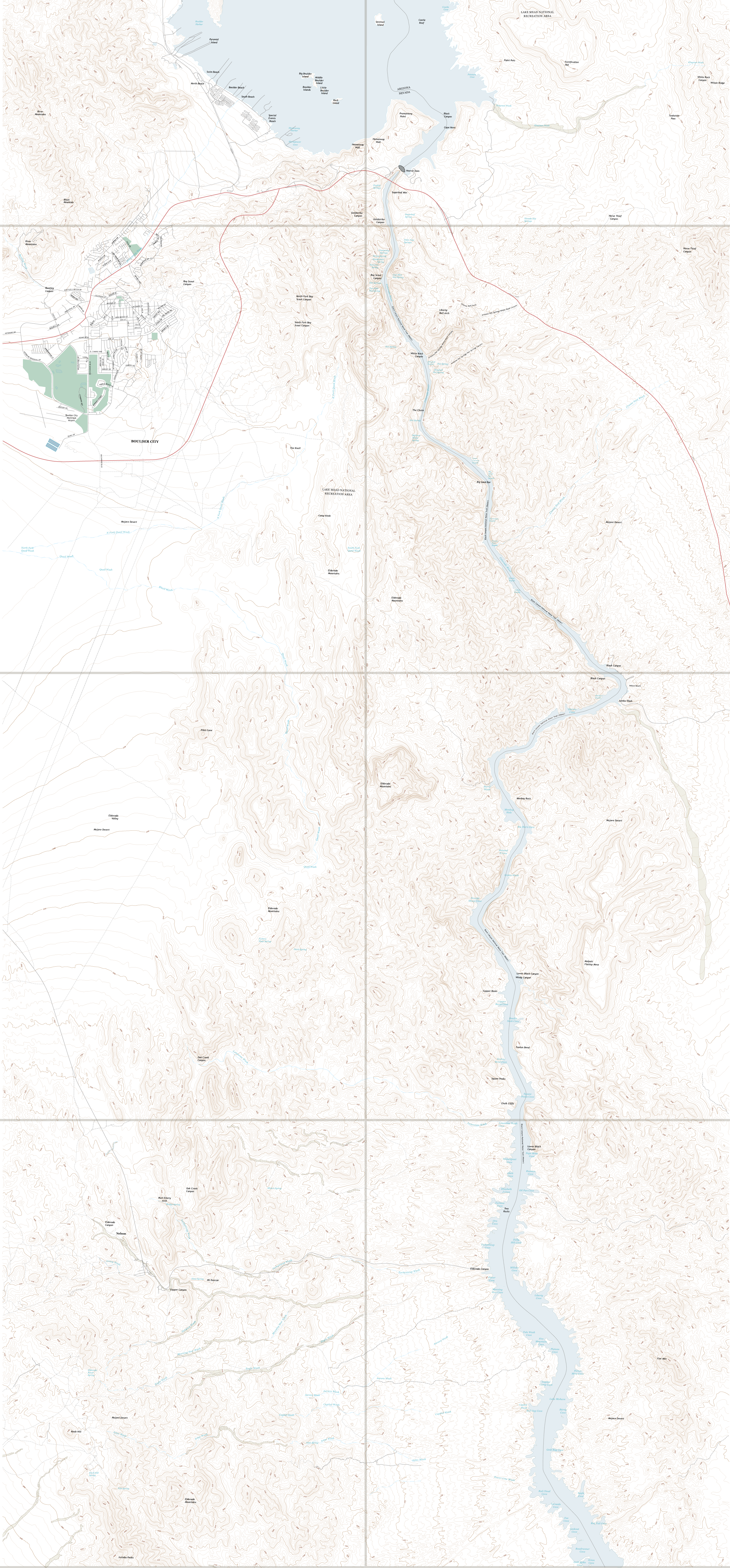
The area topography was composited from six full and portions of two other USGS topographic maps. The map names are shown in the adjacent inset. The composite was prepared by copying the lines of equal elevation and other map features from downloadable USGS pdf's and assembling those in the master map. In the case of two of the quadrangles, Hoover Dam and Boulder Beach, the information couldn't be copied because of the nature of the pdfs and had to be hand drawn. Substantial clean-up was necessary of the input information from all of the maps. Other map modifications included removal of topographic lines in some of the quadrangles to match the contour interval in others. Also, the contour interval in the Hoover Dam quadrangle does not match the other seven in the current version of the master map. Recent versions of each of the maps was used. The boundaries separating the quadrangles are shown as thick semi-transparent grey lines. Boundaries associated with the City of Boulder City, the Lake Mead National Recreation Area, and the various wilderness areas are not shown. The map can be visually panned on a computer track-pad or touch-sensitive computer, tablet or phone screen.
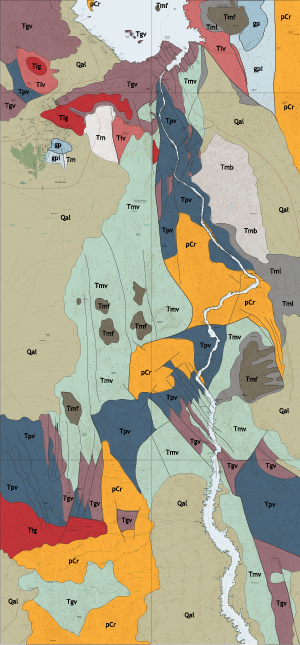
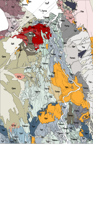
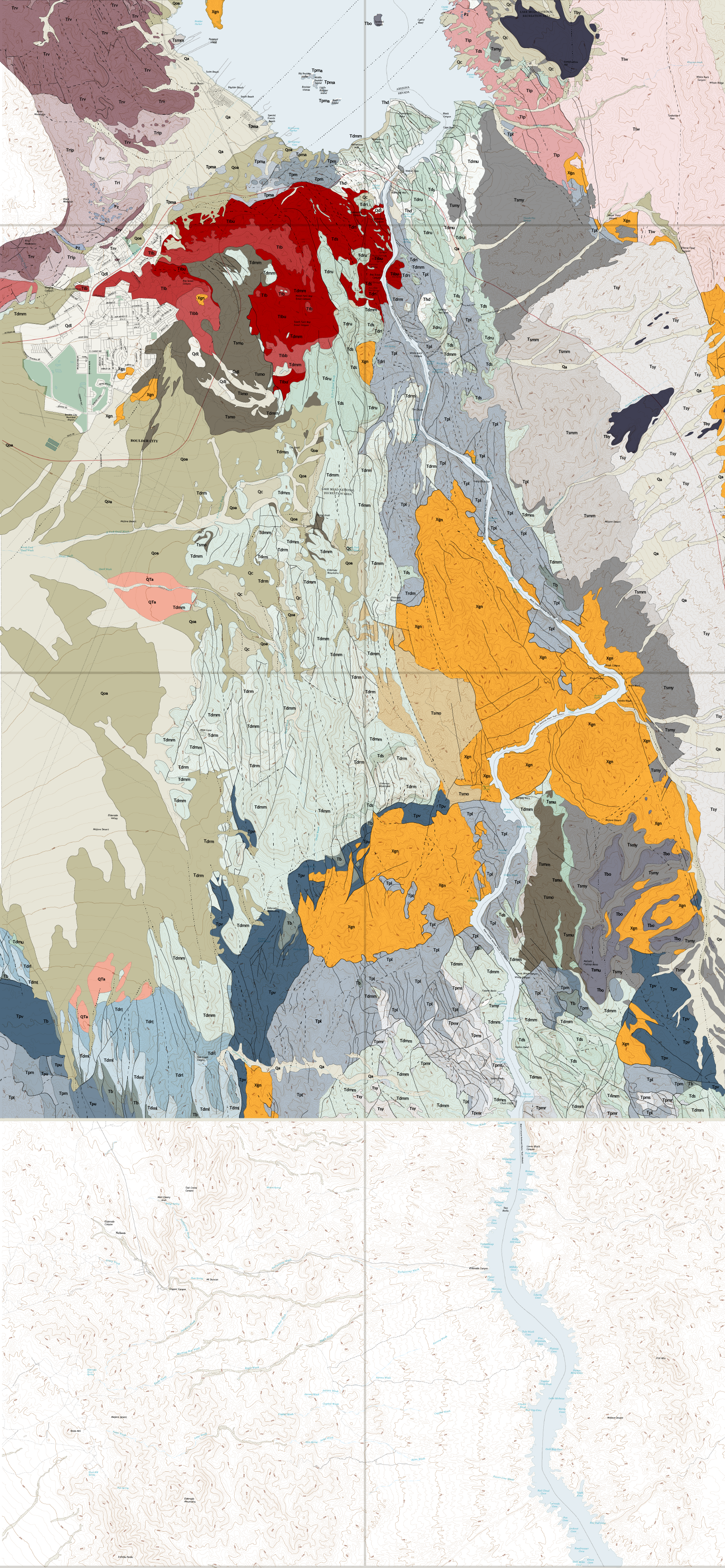
The geologic map is taken directly from a 1963 USGS map prepared by Chester R. Longwell as part of a report titled "Reconnaissance Geology Between Lake Mead and Davis Dam Arizona-Nevada". That map incorporated information from the 1961 and 1962 University of Missouri Masters and Phd theses of Tedral Kantor and Spenst Hansen covering the area around Nelson and the Eldorado mining district respectively, and several prior geologic maps and reports prepared by the USGS and the Bureau of Reclamation. This map has been modified to include the project color scheme. Some detail has been excluded related to fault and contact attributes. The map covers the same six quadrangles and two partial quadrangles covered in the topographic map and shown in the adjacent inset.
Clicking on the following geologic unit identifiers will open summaries, in a paragraph below, including the names and brief descriptions of each of the units.
The above description is taken directly from the 1963 Chester R. Longwell map and report. Because the mapping was reconnaissance in nature, the geologic units are quite general. Some of the units are named to indicate tentative petrogenetic relationships with units outside of the area covered by this map but present on the more extensive original. Later mapping, described in the following section, is more detailed and descriptive and has not continued the use of some of these naming conventions. Because of the date that the work was performed the 1963 work has a more overriding outlook, attempting to find a regional system of units and geologic history, or story, with which all mapped units are in accordance. The southern portion of this map was major gold production region at one time. The discussion of the siliceous plutonic and volcanic rocks is quite confusing and the author notes that differentiation of those rocks which predated and postdated the major volcanic sequences had not been made at that time.

The maps in this section include the adjacent smaller version of the detailed geologic map and a larger pannable version of that map below. Interactive geologic unit descriptions are presented beneath the pannable detailed geologic map.
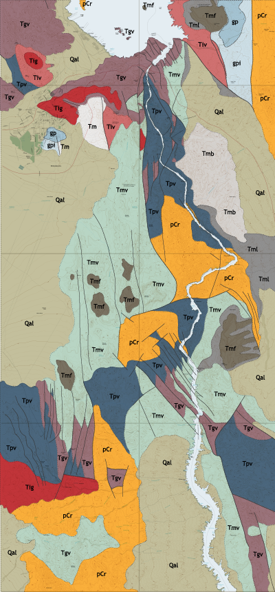
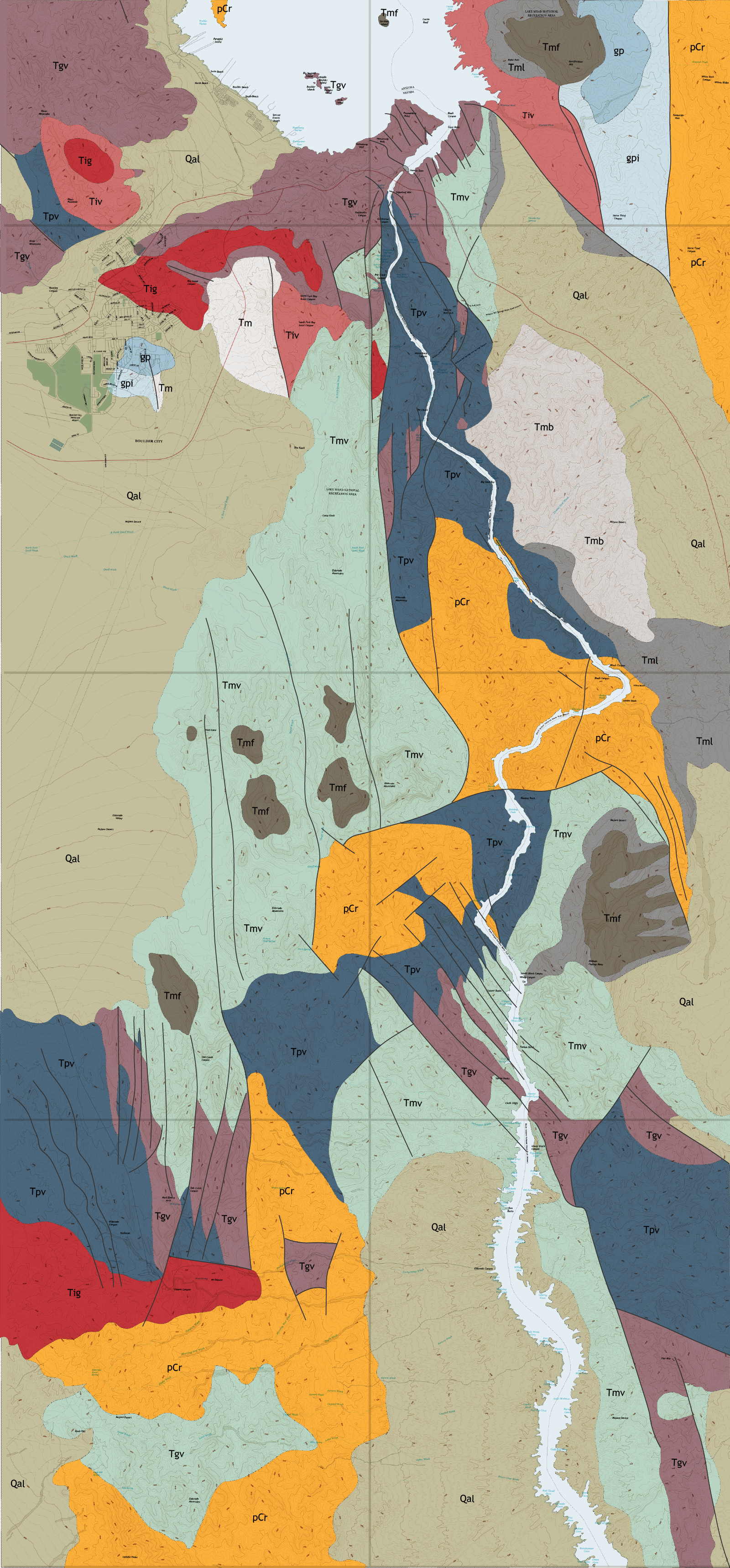
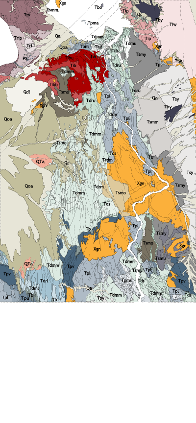
This detailed geologic map is taken directly from the 2014 USGS map prepared by Tracey J. Felger et al and titled "Preliminary Geologic Map of Black Canyon and Surrounding Region, Nevada and Arizona". This map covers an area less extensive than the USGS map. That map incorporated information from the reconnaissance mapping done by various researchers in the 1960's and before which is discussed above. Additionally, since the 1960's sub-areas contained within the area covered by this map have been mapped and studied by others. These include even more detailed USGS geologic maps of the Boulder City and Hoover Dam quadrangles. Also, further information is available from recent geologic maps of the Nelson SW, Boulder City NW and Sloan quadrangles which border the area covered by this detailed geologic map to the south and west, and a 2007 USGS report by L.S. Beard et al titled "Preliminary Geologic Map of the Lake Mead 30' x 60' Quadrangle, Clark County, Nevada and Mojave County, Arizona", extending to the north.
This detailed geologic map has been modified to include the project color scheme. Some detail has been excluded related to fault and contact attributes and local occurances of dikes and/or sills. At some point in the future these should be added to this presentation of the detailed geologic map. The map covers only four of six quadrangles and additionally the two partial quadrangles covered in the topographic and reconnaissance maps and the coverage area is shown in the adjacent inset. The Nelson and Fire Mountain quadrangles were not shown in the map upon which this is based. The content of this map was entirely hand-drawn from the 2014 map and uses the same topographic map presented above as a base.
Clicking on the following geologic unit identifiers will open, in a paragraph below, summaries including the names and brief descriptions of each of the units.
Quaternary Deposits
Cenozoic Sediments
Cenozoic Plutonic Rocks
River Mountain Volcanics
Older and Younger Basalts
Mount Davis Volcanics (upper and middle)
Mount Davis Volcanics (lower)
Tuff of Bridge Spring
Patsy Mine Volcanics
Paleozoic Sedimentary Rocks
Pre-Paleozoic Rocks
The above description is taken, almost verbatim, from the 2014 Tracey J. Felger et al map with consultation of the 2007 L.S. Beard et al report. There is not a high level of coherency with regard to unit definition and names between the two projects so cross referencing by unit names and identifiers is not clear cut. It is possible to find and correlate rock type descriptions in both. Also, as noted in the summary of the reconnaissance map unit descriptions above, some of the units described in these maps and reports are named differently than those in the reconnaissance work. The groups of mapped units in the 2014 work appear to be similar to the larger units mapped in the earlier work. Each of the unit groups can contain several units. Color coordination of the units within the groups has been made in this effort to show the distribution of both the units and the larger groupings of units. This allows for a greater ability to compare the reconnaissance mapping and the later detailed mapping. Because of the dates the later work was performed the nature of the work was less to establish an overriding thesis of the history of the rocks but more so a descriptive context where less of an importance is placed on locating spacially extensive units. In general the following correlations between the reconnaissance work and the recent work can be made: the oldest rocks, the Precambrian of the reconnaissance work, are categorized as both the Paleozoic sediments and Pre-Paleozic rocks in recent mapping. The Patsy Mine Volcanics are correlative. The Golden Door Volcanics of the early work are divided into the River Mountain Volcanics and lower Mount Davis Volcanics of the later work. The Mount Davis Volcanics of the older work are correlative with the upper and middle Mount Davis volcanics of the later. The Muddy Creek sedimentary and volcanic rocks of the older are generally correlative with both the Cenozoic sedimentary rocks and the older and younger basalts of the later, although there is overlap with the Mount Davis Volcanics. Siliceous plutonic and volcanic rocks on the older map are divided into older and younger groups separated by the major volcanic sequences. However the author notes that this differentiation is difficult and the resulting attempt is very confusing. This is also the case in the later mapping as well. Even though some of these rocks have been dated, because they are similar in both lithology and chemistry and their distribution is not clearly defined, attribution remains confusing. In the later mapping the older siliceous plutonic rocks are included with the Pre-Paleozic rocks.